Microvision eyes trucking with next-gen LiDAR strategy
Microvision says commercial trucking could emerge as one of the most practical early adopters of next-generation LiDAR technology, as fleets search for ways to reduce crashes, insurance costs, and eventually enable autonomous freight operations.
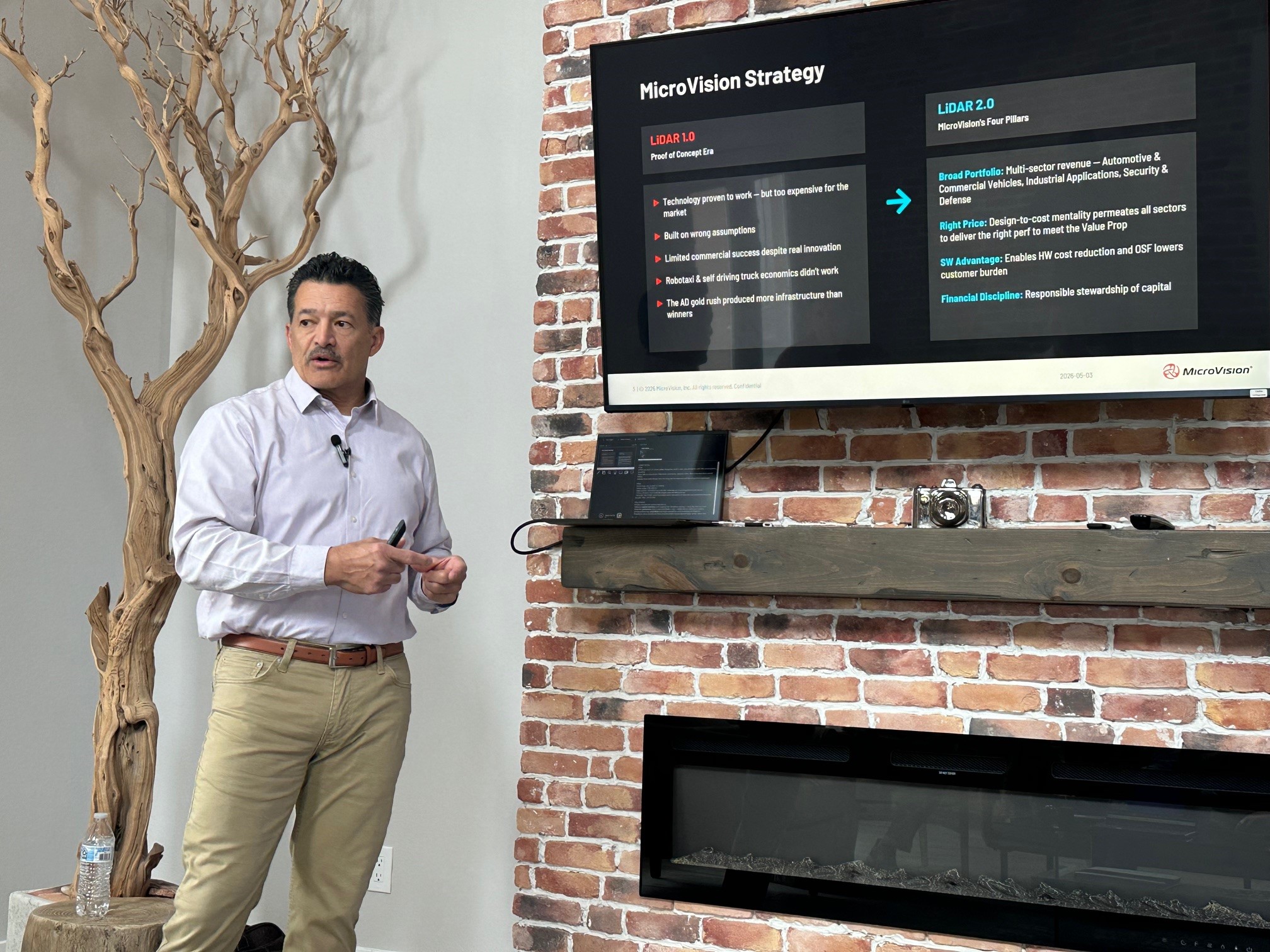
During a presentation at a House of Journalists event ahead of ACT Expo, Greg Scharenbroch, vice president of engineering at Microvision outlined the company’s “LiDAR 2.0” strategy.
He said the company is already testing its systems on commercial trucks in Europe and repositioning its technology away from the robo-taxi hype cycle that defined the industry’s first wave of investment.
“The economics just didn’t work,” Scharenbroch said of earlier autonomous vehicle programs focused on self-driving taxis and trucks.
Instead, the company is targeting more immediate commercial applications including advanced driver assistance, autonomous hub-to-hub trucking, blind-spot monitoring, yard automation, and long-range obstacle detection.
Microvision describes its LiDAR 2.0 approach as a shift toward scalable, lower-cost systems designed specifically around commercial viability. Presentation slides shown during the briefing emphasized four core pillars: broader multi-sector deployment, design-to-cost engineering, software integration, and financial discipline.
Scharenbroch said one of the key advantages of LiDAR over conventional camera-based systems is its ability to detect hazards far beyond headlight range.
“If a truck is traveling down the highway at a certain speed, it needs to look out so far and see something in the dark with very low reflectivity on the ground … and be able to detect it in time to provide enough advanced warning to allow the driver to do an evasive maneuver or slow down,” he explained
The company said its current long-range systems can detect objects at roughly 820 feet (250 meters), while an ultra-long-range sensor under development could eventually scale to approximately one kilometer.
Microvision also outlined the financial case for LiDAR adoption in trucking. Presentation materials claimed advanced safety systems could deliver accident cost avoidance of approximately four cents per mile, reduce average accident costs by 15%, lower insurance costs by up to 20%, and improve operational efficiency by six to eight cents per mile.
Scharenbroch cited industry crash statistics showing roughly 5,000 annual fatalities involving Class 8 trucks in the U.S., with many crashes tied to rear-end collisions and human error.
“There are hundreds, probably thousands, of studies over the years to show that up to 90% of all crashes are due to some form of human error,” he said.
The company believes LiDAR-equipped automated systems could eventually help fleets address driver shortages and improve tractor utilization by enabling more continuous operations.
“L4, L5 doesn’t have limits on how long a driver can drive,” Scharenbroch said, referring to higher levels of autonomy. “You don’t have assets sitting in a terminal not being used. You can run these 24/7.”
Microvision recently acquired assets from bankrupt LiDAR developer Luminar, including engineering staff, manufacturing infrastructure, and customer programs tied to the company’s Iris and Halo sensor platforms.
Scharenbroch said the acquisition brought approximately 85 employees into Microvision, most of them engineers with automotive production experience.
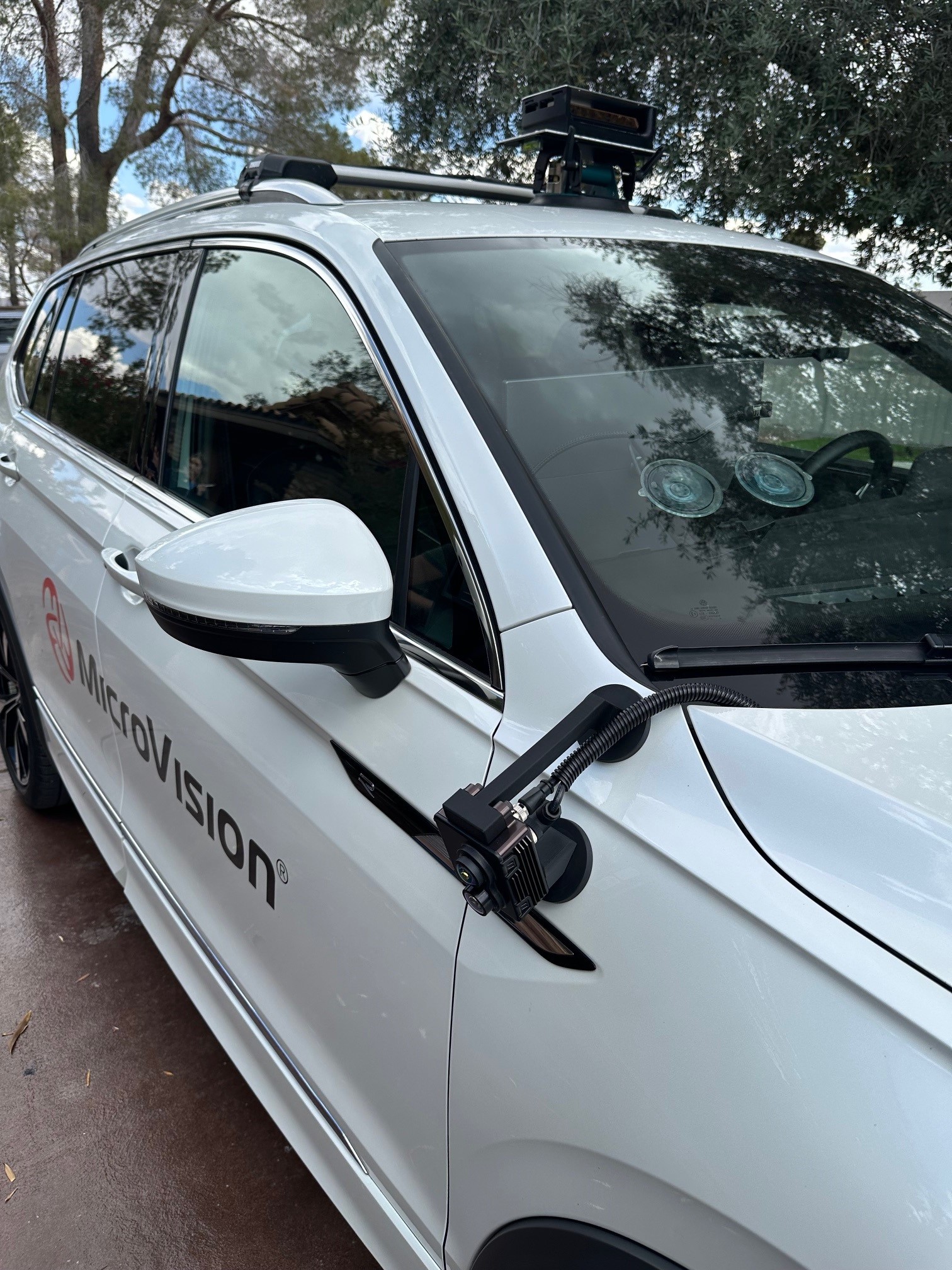
The company demonstrated a vehicle equipped with one forward-facing Halo sensor and multiple Movia short-range sensors to provide near-360-degree coverage around the vehicle.
Beyond trucking, Microvision is adapting the same sensor and software architecture for warehouse automation, mining haul trucks, drones, marine navigation, and military applications.
On the road
A live vehicle demonstration showed how Microvision’s sensors and software work together in real time, combining long-range and short-range LiDAR into a single perception system.
During a ride on Las Vegas streets, the system fused data from four sensors — a forward-facing long-range unit and three short-range sensors mounted around the vehicle — to create a continuous 360-degree view of the surroundings.
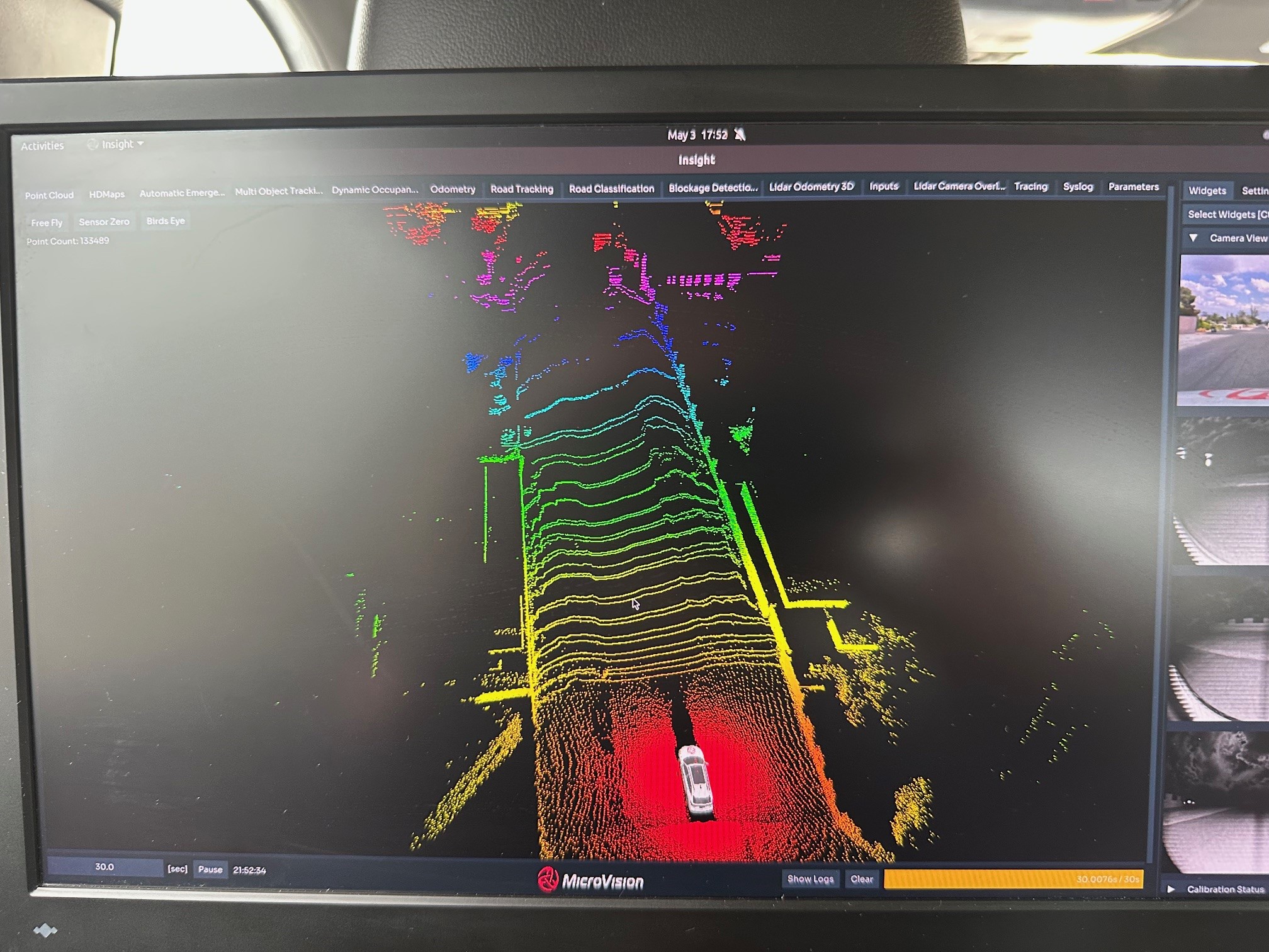
Objects were not only detected but classified and tracked, with the system identifying vehicles, road surfaces, and lane markings while predicting movement based on speed and direction.
The system operates at roughly 10 frames per second, continuously updating a 3D map of the environment and tracking objects more than 200 meters ahead.
One key capability demonstrated was operation without GPS. The system created a real-time map of the route, then localized the vehicle within that map using only LiDAR data — a feature the company says could be valuable in terminals, yards, or areas where GPS signals are unreliable.
Engineers also demonstrated how the system filters out moving objects when building maps, focusing only on static infrastructure such as buildings and road geometry. That allows fleets to share and update maps across vehicles using small data updates rather than full remapping.
The demo also highlighted how sensor roles are split: long-range LiDAR is pitched forward to detect hazards hundreds of meters ahead, while short-range sensors fill in blind spots around the vehicle.
“That’s how you get true 360-degree coverage,” the engineer said, noting the system supports functions such as automatic emergency braking and steering using both long- and short-range inputs.
Microvision also demonstrated dynamic scanning, where the system adjusts its focus depending on the driving environment — prioritizing distance on highways and higher detail closer to the vehicle in urban settings.
Have your say
This is a moderated forum. Comments will no longer be published unless they are accompanied by a first and last name and a verifiable email address. (Today's Trucking will not publish or share the email address.) Profane language and content deemed to be libelous, racist, or threatening in nature will not be published under any circumstances.