Precise plowing in Alaska being guided by GPS

THOMPSON PASS, Alaska — If the snow plow drivers who work the road through Alaska’s Thompson Pass worried about driving in zero-visibility white-out conditions, the path would never be cleared. During the average winter over the past 50 years, the Thompson Pass on the Richardson Highway near Valdez receives about 500 inches (1,270 cm) of snow. The area claims several snowfall records. In 1955 a single-day accumulation record was set at 62 inches (160 cm), and during the winter of 1952-53 a record 971.1 inches (2,474 cm) landed in the area.
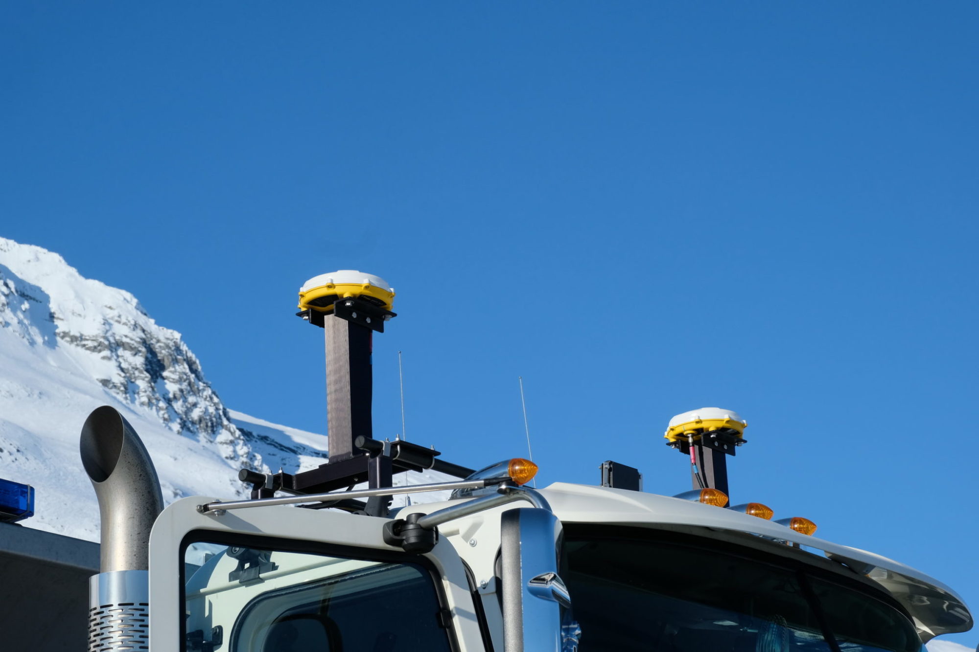
It snows a lot through Thompson Pass, yet the snow plow crews there can keep running thanks to an ultra-precise GPS system that’s accurate to within two centimeters, or less than one inch.
“In the U.S., the paint stripe on a highway lane is four inches wide, so this GPS is accurate enough to know when the wheel is going over the inside of the line,” says Craig Shankwitz, part of the system’s original development team at the University of Minnesota.
For snow plow drivers like Mark Hanson of the Department of Transport-ation station at Thompson Pass, it means the difference between driving blind through a blizzard and still knowing exactly where the truck is on the road – even when everything out front is just a white blur.
“These trucks are all set up with differential GPS systems, a guidance system for getting you a virtual image of where you are on the road,” Hanson says. “It’s a really good way of keeping you on the road… You can cut a really nice, true, straight line down through a whiteout. And that way you have less passes to get the road the full width.”
In the cab, drivers have a display that shows the truck’s position relative to the lane markings on a moving map. The center line appears as a yellow dashed line, while the outer lane markings appear as solid white lines. If the truck travels over the lane marking, a solid red line appears, warning the driver he or she is crossing out of the prescribed lane.
In addition to the in-cab display, there are motorized vibrators in the driver’s seat that activate if a truck crosses out of the lane. If it crosses over the center line – drifting left – a vibrator in the left side of the seat goes off. Drift to the right, toward the shoulder, and the right-side vibrator goes off. It’s a natural human reaction to move away from something you don’t expect, so almost subconsciously the driver steers away from the source of the vibration, centering the truck in its lane.
The displays are of such resolution that drivers, with a little practice, can steer the plows along a winding roadway using just the image on the display. As well as the GPS, the plows are equipped with forward-looking radar to warn of objects in the road, such as abandoned cars.
Systems were first installed in snow plows by the Alaska DOT in 2003. The technology is ancient by today’s standards, but it remains state-of-the-art since nothing better has come along.
The main technology is called Dual Frequency Carrier Phase GPS, says Shankwitz. It uses signals from two separate satellite networks – the civilian signals from the American GPS satellite constellation and, in the case of the Alaskan snow plows, signals from the Russian GPS constellation of satellites called GLONASS (Global Navigation Satellite System).
The trucks have two GPS receivers mounted atop the cab. These receivers cost about $10,000 each, Shankwitz says. “That’s probably why this hasn’t been deployed in many other areas. It’s just too expensive and most applications do not require that level of accuracy.”
The two-centimeter accuracy actually comes from a third receiver – a high-precision stationary ground-based receiver perched atop a microwave communications tower in nearby Valdez. It’s accurate to within millimeters and it acts as a reference receiver for the plow-mounted systems.
The receiver is essentially looking at the code and then counting the number of wavelengths traveling between the satellites and antenna, Shankwitz says. “The difference between the wavelengths is about two centimeters, so when we talk about that two-centimeter accuracy, it’s actually the possible variance you have in the number of wavelengths that get to that satellite. It counts the number of wavelengths from a couple of satellites in geosynchronous orbit 26,000 km above the earth.”
The base station computes the discrepancy between where it knows the stationary GPS receiver is and where the truck-mounted GPS thinks it is. The system calculates the error and sends that information to the trucks via VHF radio. Computers on the trucks use this corrected derivation to calculate a truck’s actual position to within two centimeters. And all this happens thousands of times every second.
The city of Minneapolis currently uses a newer version of this system on some transit buses that operate around the Twin Cities. When a road’s shoulder is obscured by snow, the operators can still track their position using a display similar to the one on Thompson Pass snowplows. But the Minneapolis systems communicate over a cellular network rather than a VHF radio.

GPS and future autonomous vehicles
A highly accurate GPS seems like the perfect navigation solution for autonomous vehicles. But the system described above, developed by MTS and the University of Minnesota, is patent-protected for a couple more years. Not that it matters much. The U.S. government is about to roll out a new constellation of GPS satellites called GPS III.
“Instead of two frequencies on GPS that we use now, civilian and military, GPS III will give a third frequency when the constellation is fully populated,” says Shankwitz. “When that happens we’ll have 10-centimeter accuracy rather than two [centimeters], but without the high cost of the patent and the infrastructure from the base station that supports the operation in Alaska and other places. All of a sudden the cost comes way down, and GPS technology becomes much more viable.”
Many of the autonomous vehicles that are being developed combine radar (for collision avoidance) and Lidar to see their way in the world. GPS is used as well, but for navigation rather than managing lanes. GPS III could bring to autonomous vehicles the kind of precise “vision” enjoyed by snowplows clearing Thompson Pass. But there’s still one more thing needed to make it work: the map database.
“Google has mapped much of the planet to very accurate dimensions. In fact, they’ve got map database technology that really no one else has,” explains Shankwitz. “So, when that GPS III constellation becomes populated, the GPS receivers – instead of being expensive instruments – basically become a commodity. That’s when Google goes nuts and owns the entire planet.”
To prevent Google from having a global grip on high-definition mapping, a consortium of German automakers including Audi, Volkswagen, Daimler and BMW bought former mapping provider NAVTEQ’s database for US $3 Billion in 2017, the New York Times reported.
“The Germans realized that GPS III is coming [with] a 10-centimeter accuracy that is sufficient to guide an autonomous vehicle,” said Shankwitz.
“GPS solves the weather sensitivity problem that we now have with image-based systems. And you combine that with the map database, you’ve got the guidance thing covered,” he adds. “As radar and Lidar technology evolve [to support collision avoidance], you’ve got all the elements you need for a functional, all-weather, autonomous vehicle.”
And it all started with a couple of snowplows in Alaska.
- An earlier version of this story has been updated to reflect the proper spelling of Mark Hanson’s name. Today’s Trucking regrets the error.
Have your say
This is a moderated forum. Comments will no longer be published unless they are accompanied by a first and last name and a verifiable email address. (Today's Trucking will not publish or share the email address.) Profane language and content deemed to be libelous, racist, or threatening in nature will not be published under any circumstances.